Back Wrangeleiland Afrikaans جزيرة رانجل Arabic جزيره رانجل ARZ Vrangel adası Azerbaijani Востраў Урангеля Byelorussian Врангел (остров) Bulgarian ভ্রাংগেল দ্বীপ Bengali/Bangla Illa de Wrangel Catalan Wrangel Island (pulo sa Rusya) CEB Wrangelův ostrov Czech
 Wrangel Island in October 2018 | |
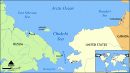
 Location of Wrangel Island | |
| Geography | |
| Location | Near Chukchi Sea |
| Coordinates | 71°14′N 179°25′W / 71.233°N 179.417°W |
| Area | 7,600 km2 (2,900 sq mi) |
| Highest elevation | 1,096 m (3596 ft) |
| Highest point | Soviet Mountain |
| Administration | |
| Federal District | Far Eastern |
| Autonomous Okrug | Chukotka |
| Demographics | |
| Population | 0 |
| Official name | Natural System of Wrangel Island Reserve |
| Type | Natural |
| Criteria | ix, x |
| Designated | 2004 (28th session) |
| Reference no. | 1023rev |
| Region | Asia |

Wrangel Island (Russian: О́стров Вра́нгеля, romanized: Ostrov Vrangelya, IPA: [ˈostrəf ˈvrangʲɪlʲə]; Chukot: Умӄиԓир, romanized: Umqiḷir, IPA: [umqiɬir], "island of polar bears"[1]) is an island of the Chukotka Autonomous Okrug, Russia. It is the 92nd largest island in the world and roughly the size of Crete. Located in the Arctic Ocean between the Chukchi Sea and East Siberian Sea, the island lies astride the 180th meridian. The International Date Line is therefore displaced eastwards at this latitude to keep the island, as well as the Chukchi Peninsula on the Russian mainland, on the same day as the rest of Russia. The closest land to Wrangel Island is the tiny and rocky Herald Island located 60 kilometres (32 nautical miles) to the east.[2] Its straddling the 180th meridian makes its north shore at that point both the northeasternmost and northwesternmost point of land in the world by strict longitude; using the International Date Line instead those respective points become Herald Island and Alaska's Cape Lisburne.
Most of Wrangel Island, with the adjacent Herald Island, is a federally-protected nature sanctuary administered by Russia's Ministry of Natural Resources and Environment. In 1976, Wrangel Island and all of its surrounding waters were classified as a "zapovednik" (a "strict nature reserve") and, as such, receive the highest level of protection, excluding virtually all human activity other than conservation research and scientific purposes. In 1999, the Chukotka Regional government extended the protected marine area to 24 nmi (44 km) offshore. As of 2003, there were four rangers who reside on the island year-round, while a core group of about 12 scientists conduct research during the summer months. Wrangel Island was home to the last surviving population of woolly mammoths, with radiocarbon dating suggesting the species persisted on the island until around 4,000 years ago (2000 BC).
- ^ Леонтьев, Владилен Вячеславович; Новикова, Клавдия Александровна (1989). Меновщиков, Георгий Алексеевич (ed.). Топономический словарь Северо-Востока СССР (in Russian). Magadan: Магаданское книжное издательство. pp. 108, 384. ISBN 5-7581-0044-7.
- ^ Kosko, M.K., M.P. Cecile, J.C. Harrison, V.G. Ganelin, N.V., Khandoshko, and B.G. Lopatin, 1993, Geology of Wrangel Island, Between Chukchi and East Siberian Seas, Northeastern Russia. Bulletin 461, Geological Survey of Canada, Ottawa Ontario, 101 pp.
© MMXXIII Rich X Search. We shall prevail. All rights reserved. Rich X Search